


وصف لـ Dynavix Navigation, Traffic Information & Cameras
+ Free offline GPS navigation for Android.
+ Free lifetime updates of map data several times a year. Maps are stored inside the device, and therefore available wherever you are.
+ Intelligent route guidance using accurate traffic information and traffic cameras, in real-time.
______________________________________
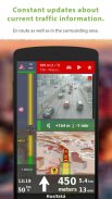
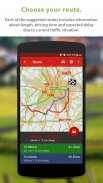
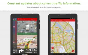
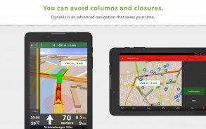
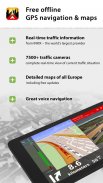
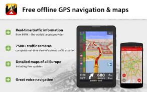
Using real-time traffic information to find the fastest route: Dynavix uses traffic data received on the basis of anonymous collection of data on the movement of other vehicles. With this feature, you can avoid e.g. impassable stretches in the morning or afternoon rush hour. The function of real-time traffic information covers 87% of the EU population.
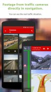
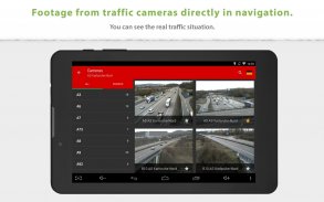
Snapshots from online traffic cameras near the planned route: Only Dynavix allows you to view data from traffic cameras located around the calculated route. In addition, Dynavix allows you to create custom lists of cameras, viewing data from cameras in the map, and other features. Dynavix currently supports access to over 7,500 traffic cameras across Europe.
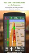
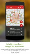
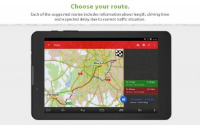
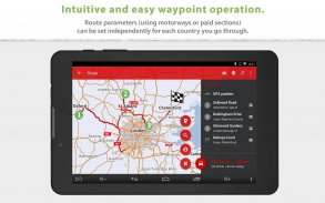
Advanced route planning using waypoints: The new Dynavix also significantly improves route planning with the use of waypoints. The planning is now very clear and adapted for use on mobile phones and tablets.
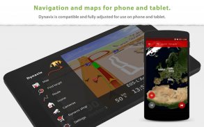
High-quality accurate maps: New Dynavix uses OpenStreetMap data. We believe the strength of the international community and current practice shows that OpenStreetMap are very detailed and often better than the maps from other providers.
The main functions of Dynavix:
• Turn-by-turn offline voice navigation using real-time traffic information (e.g. traffic jams or road closures) to find the fastest route (data provider INRIX)
• Views from online traffic cameras near the planned route
• Lifetime free map updates several times a year
• Advanced route planning using waypoints with the possibility of avoiding toll roads in certain countries or along the entire route
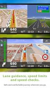
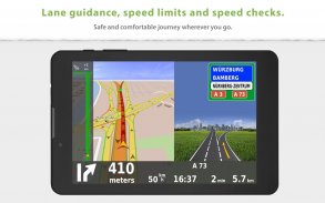
• Lane assistant and highway labels
• Full-text address search
• Alternative routes
• Support for voice commands via Bluetooth handsfree (Media mode or Phone call)
• Journey stats with possible export to *.csv
• Large database of points of interest
• 2D / 3D map view
• Speed check notification (with the possibility of importing community database radars)
• Speed limit warning
• Pedestrian navigation
• Wide range of view options personalization
Maps (stored in device memory):
Albania, Andorra, Belarus, Bosnia-Herzegovina, Bulgaria, Croatia, Czech Republic, Austria, Belgium, Denmark, Estonia, Finland, France, Germany, Gibraltar, Greece, Hungary, Italy, Ireland, Latvia, Liechtenstein, Lithuania, Luxembourg, Malta, Macedonia, Montenegro, Monaco, Netherlands, Norway, Slovakia, Slovenia, Spain, Poland Portugal, Romania, San Marino, Serbia, Sweden, Switzerland, Turkey, United Kingdom, Vatican City
Traffic information is available in the following countries:
Andorra, Austria, Belgium, Czech Republic, Denmark, Finland, France, Germany, Ireland, Italy, Liechtenstein, Luxembourg, Netherlands, Norway, Poland, Portugal, Slovakia, Spain, Sweden, Switzerland, United Kingdom
______________________________________
For more information visit our website www.dynavix.com
If you like Dynavix navigation, we encourage you to write at least a short review.
Notes:
• Navigation can dramatically decrease battery life even running in the background. Make sure you keep the phone connected to the charger when using navigation.
• The real-time traffic information function requires an Internet connection.
+ الملاحة GPS مجانا حاليا لالروبوت.
+ تحديثات مجانية مدى الحياة لبيانات الخرائط عدة مرات في السنة. يتم تخزين الخرائط داخل الجهاز ، وبالتالي تتوفر أينما كنت.
+ توجيه توجيه ذكي باستخدام معلومات حركة المرور الدقيقة وكاميرات المرور ، في الوقت الفعلي.
______________________________________
عن طريق معلومات عن حركة المرور في الوقت الحقيقي لإيجاد الطريق الأسرع: Dynavix يستخدم بيانات حركة المرور وردت على أساس جمع البيانات مجهول على حركة المركبات الأخرى. باستخدام هذه الميزة ، يمكنك تجنبها على سبيل المثال. تمتد سالكة في الصباح أو في ساعة الذروة في فترة ما بعد الظهر. تغطي وظيفة معلومات حركة المرور في الوقت الفعلي 87٪ من سكان الاتحاد الأوروبي
لقطات من كاميرات المرور على الانترنت بالقرب من المسار المخطط: فقط Dynavix يسمح لك لعرض البيانات من الكاميرات المرورية الواقعة على بعد نحو الطريق المحسوبة. بالإضافة إلى ذلك ، Dynavix يسمح لك بإنشاء قوائم مخصصة من الكاميرات ، وعرض البيانات من الكاميرات في الخريطة ، وغيرها من الميزات. تدعم Dynavix حاليًا الوصول إلى أكثر من 7500 كاميرا عبر أوروبا
خيارات متقدمة تخطيط الطريق باستخدام نقاط الطريق: وDynavix الجديدة أيضا تحسن كبير في تخطيط الطريق مع استخدام نقاط الطريق. أصبح التخطيط الآن واضحًا جدًا ومكيفًا للاستخدام على الهواتف المحمولة والأجهزة اللوحية
خرائط دقيقة عالية الجودة: تستخدم Dynavix الجديدة بيانات OpenStreetMap. نحن نؤمن بأن قوة المجتمع الدولي والممارسة الحالية تظهر أن OpenStreetMap مفصّل جدًا وغالبًا ما يكون أفضل من الخرائط المقدمة من مزوّدين آخرين.
الوظائف الرئيسية لـ Dynavix:
• بدوره عن طريق بدوره حاليا الملاحة الصوتية باستخدام معلومات عن حركة المرور في الوقت الحقيقي (مثل الاختناقات المرورية أو إغلاق الطرق) للعثور على الطريق الأسرع (موفر البيانات INRIX)
• المشاهدات من كاميرات حركة المرور على الإنترنت بالقرب من الطريق المخطط
• تحديثات مجانية مدى الحياة خريطة عدة مرات في السنة
• تخطيط الطريق المتقدم باستخدام نقاط الطريق مع إمكانية تجنب الطرق ذات الرسوم في بعض البلدان أو على طول الطريق بأكمله
• مساعد المسار وشارات الطرق السريعة
• البحث عن عنوان النص الكامل
• طرق بديلة
• دعم للأوامر الصوتية عبر تقنية Bluetooth غير اليدوية (وضع الوسائط أو مكالمة هاتفية)
• احصائيات الرحلة مع إمكانية التصدير إلى * .csv
• قاعدة بيانات كبيرة من النقاط المثيرة للاهتمام
• عرض الخريطة ثنائي / ثلاثي الأبعاد
• إخطار فحص السرعة (مع إمكانية استيراد رادارات قاعدة بيانات المجتمع)
• تحذير حد السرعة
• الملاحة المشاة
• مجموعة واسعة من تخصيص خيارات العرض
الخرائط (المخزنة في ذاكرة الجهاز):
ألبانيا، أندورا، روسيا البيضاء، البوسنة والهرسك، بلغاريا، كرواتيا، جمهورية التشيك، النمسا، بلجيكا، الدنمارك، استونيا، فنلندا، فرنسا، ألمانيا، جبل طارق، اليونان، هنغاريا، إيطاليا، أيرلندا، لاتفيا، ليختنشتاين، ليتوانيا، لوكسمبورغ، مالطا ومقدونيا والجبل الأسود، موناكو، هولندا، النرويج، سلوفاكيا، سلوفينيا، اسبانيا، بولندا البرتغال، رومانيا، سان مارينو، صربيا، السويد، سويسرا، تركيا، المملكة المتحدة، الفاتيكان المدينة
تتوفر معلومات حركة المرور في البلدان التالية:
أندورا، النمسا، بلجيكا، جمهورية التشيك، الدنمارك، فنلندا، فرنسا، ألمانيا، ايرلندا، ايطاليا، ليختنشتاين، لوكسمبورغ، هولندا، النرويج، بولندا، البرتغال، سلوفاكيا، اسبانيا، السويد، سويسرا، المملكة المتحدة
______________________________________
لمزيد من المعلومات ، يرجى زيارة موقعنا على الانترنت www.dynavix.com
إذا كنت تحب التنقل Dynavix ، فنحن نوصيك بكتابة مراجعة قصيرة على الأقل
ملاحظات:
• يمكن الإنتقال تقليل عمر البطارية بشكل كبير حتى تعمل في الخلفية. تأكد من الحفاظ على الهاتف المتصل الشاحن عند استخدام جهاز الملاحة.
• في الوقت الحقيقي وظيفة معلومات عن حركة المرور تتطلب اتصال بالإنترنت.
Dynavix Navigation, Traffic Information & Cameras - إصدار 6.6.25
(09-02-2024)Dynavix Navigation, Traffic Information & Cameras - معلومات APK
نُسخة APK: 6.6.25الحزمة: com.dynavix.navigationآخر إصدار من Dynavix Navigation, Traffic Information & Cameras
تطبيقات من الفئة نفسها
قد يعجبك أيضًا...


